|
Expect a gorgeous Wednesday all across the area with highs in the mid to upper 80s. Some spots in the extreme southern portions may even reach close to 90! How is that for early May? A stray shower is possible in the higher elevations. Rain chances return Thursday for Chattanooga, Thursday night for Knoxville and the Tri-Cities. On the go? Hear our forecasts on i92.5 and 95.5 The Block in Knoxville and Z93 Non-Stop Hip-Hop in Chattanooga! 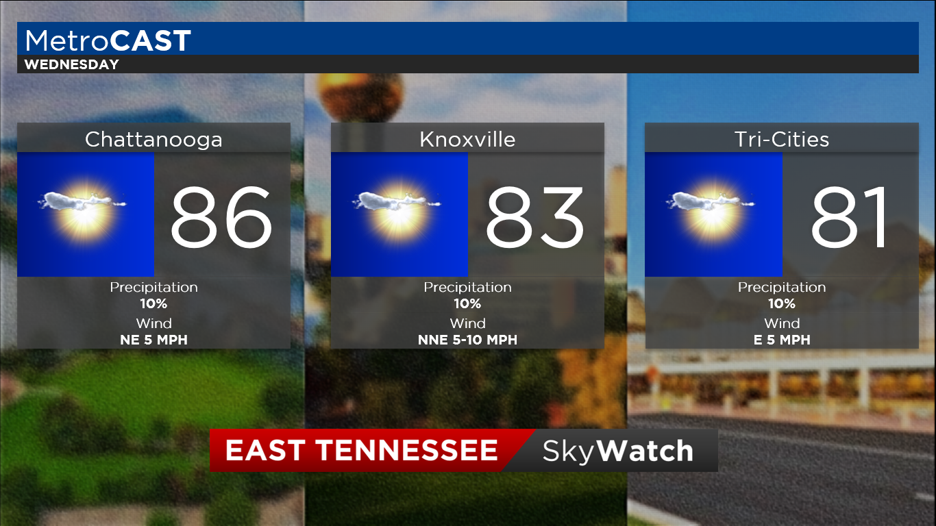
0 Comments
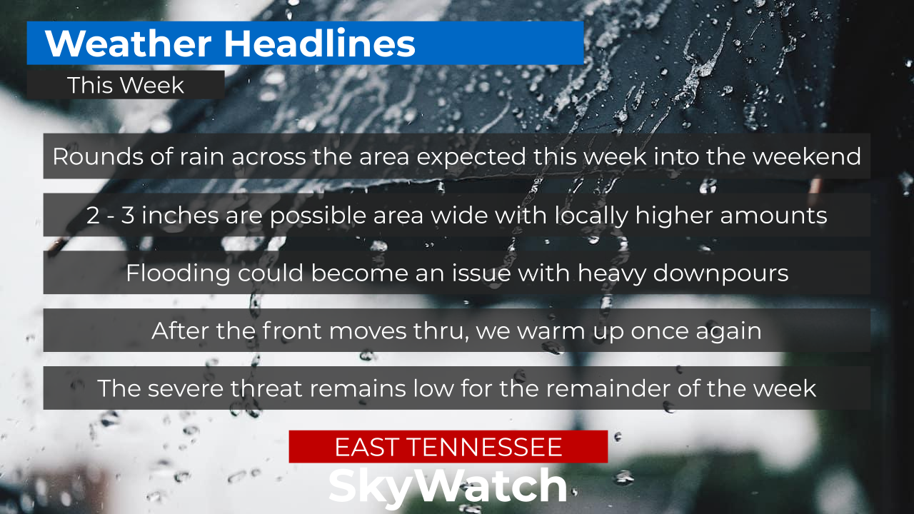
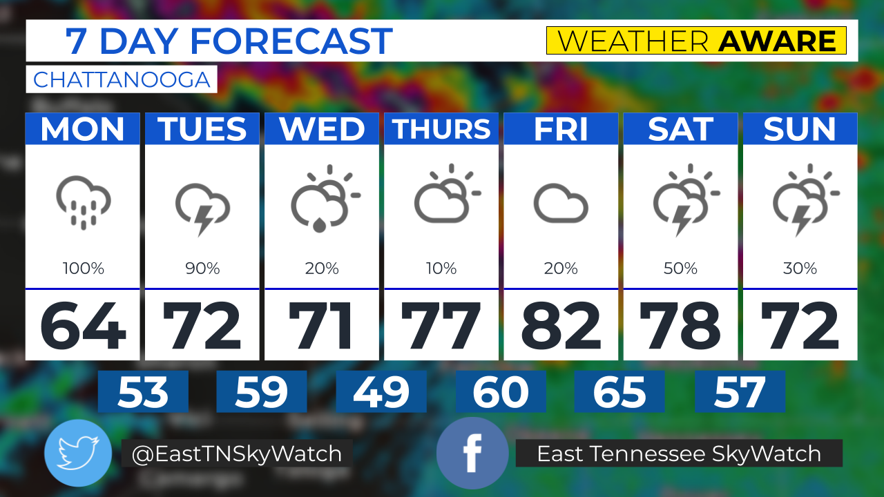
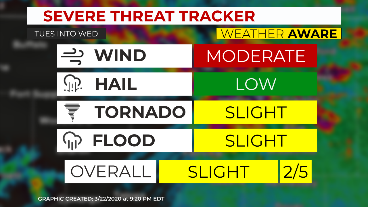
We're keeping an eye on Wednesday afternoon and overnight into the early hours of Thursday morning. As of late Monday evening, The NWS Storm Prediction Center has put the northern part of the area in a SLIGHT risk, while areas south Interstate 40 are in the ENHANCED risk. The main threats are damaging winds in excess of 60 mph, flash flooding, and an isolated tornado. The threat of large hail remains on the low end. Timing looks to be concentrated from 3pm EDT Wednesday to around 2am EDT Thursday. As of late Monday evening, models have been suggesting a line of discrete supercells across the area around the evening hours (6-9pm EDT Wed). If the trend continues, the SPC may increase the tornado and damaging wind potential. After most of the rain ends, the center of the low pressure will begin to make its way through the area. Wind will pick up through the night and may blow around unsecured objects. This is a developing situation, as we get closer to the event, more details will follow as we are able to fine-tune the forecast. Stay with East Tennessee SkyWatch and Appalachian Highlands Weather. We'll keep you advised. Follow East Tennessee Skywatch and Appalachian Highlands Weather on Facebook and Twitter! 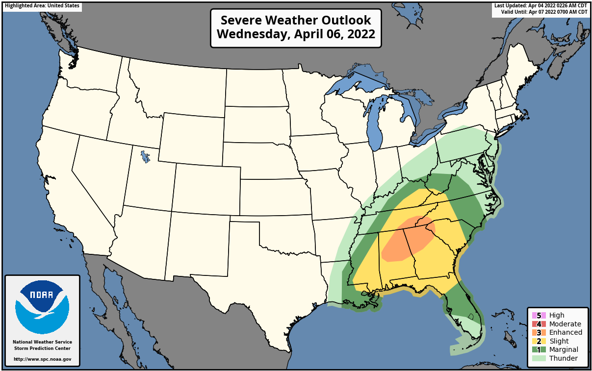 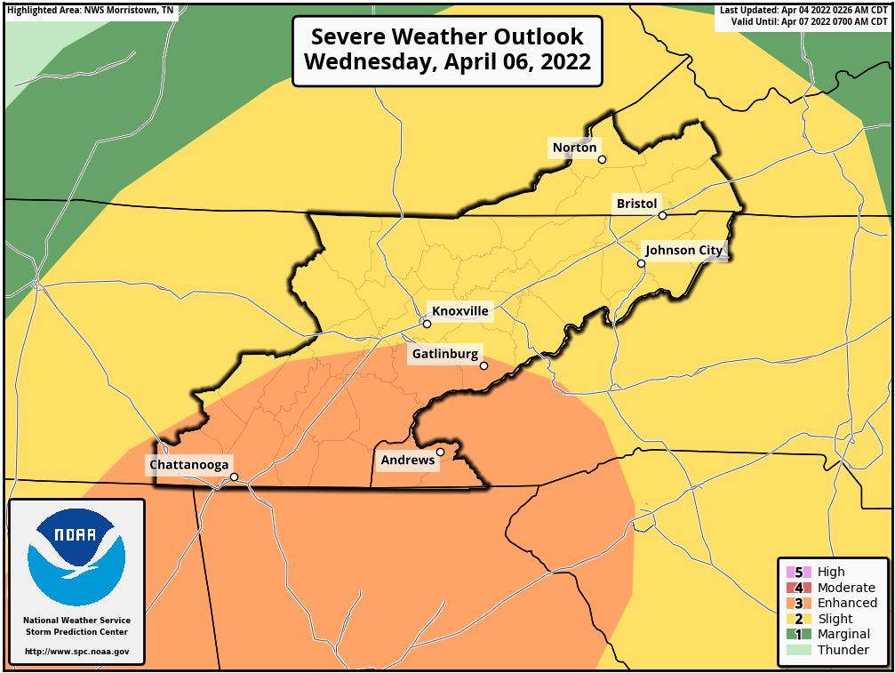 It's time to head back to the classroom! And we have your weather forecast for that exciting day! Expect scattered showers and thunderstorms tomorrow area wide along with partly cloudy skies, heat, and humidity. Most of the thundershowers will be concentrated in the higher elevations, however a few could sneak into the lower elevations. Rain chances increase thru the week. 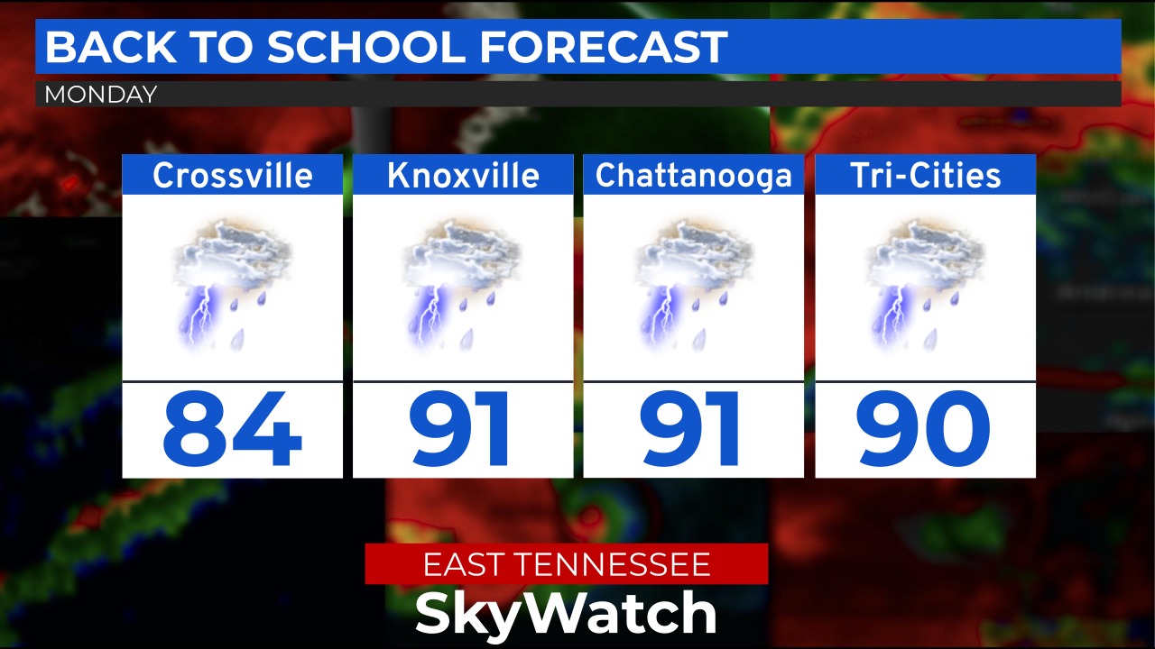 After a wet and gloomy week, warm and sunny weather will make a return to the region by next week. We still will have to dodge hit and miss thunderstorms as well as we go through the Memorial Day weekend as well. Almost all of this the days week will be similar weather-wise. Sunday: Temperatures will rise to the mid to upper 80s in Knoxville (84) and Chattanooga (87) but just a few degrees cooler in the Tri-Cities (81) and Crossville (82). Showers and a few thunderstorms will develop during the day and will persist through the evening. One or two strong storms are possible but the greatest chance of severe weather is in Southeast Tennessee. We're giving a 45% chance of showers and thunderstorms area wide. IF there are any severe thunderstorms, they will be short lived. The main threats will be damaging winds and isolated large hail. The tornado threat is very slim. Memorial Day (Monday): The summer weather pattern continues as will warm up. Area wide, highs will be in the mid to upper 80s as well. Knoxville near 86, Chattanooga near 87, Tri-Cities near 85, and Crossville around 83. Pop-up showers and thunderstorms are expected with the chances of precipitation around 50%-60% while higher chances exist into the Smokies. If you have any outdoor plans, keep a close eye on the sky. Remember, when thunder roars, go indoors! Tuesday: A mix of sun and clouds can be expected with a few showers and thunderstorms. Temperatures will cool down by a degree or two but will still remain in the Mid 80s. However, the cooler temperatures will be in Southeast Tennessee. Tuesday Highs: Knoxville near 85, Chattanooga near 84, Tri-Cities near 85, and Crossville around 82. Showers and thunderstorms may pop up during the afternoon with a low potential for severe thunderstorms. Precipitation chances will be around 30%-40% area wide. Wednesday: Tuesday's twin. a mix of sun and clouds area wide with a chance of some pop-up showers and thunderstorms across East Tennessee. Highs in the mid 80's area-wide. Wednesday's Highs: Knoxville around 85, Chattanooga around 86, Tri-Cities around 85, and Crossville near 83. Chances of precipitation area-wide will be 30%-50% with the greatest chance of showers and thunderstorms in the mountains and higher terrain. However, a few showers and thunderstorms are possible in the valley as well. Thursday: A mix of sun and clouds with a chance of pop-up showers and thunderstorms. Highs in the mid 80s with a 30%-40% chance of precipitation area-wide. Stay safe and healthy! - Eli Bray Today (Tuesday) will be mild and the perfect weather to get outside and enjoy the sunshine. Rain and an occasional rumble of thunder returns tomorrow. 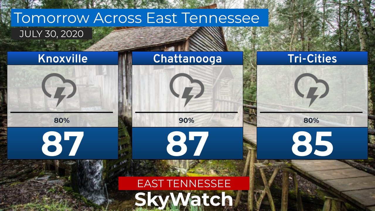 Most of the area is in a Level 2 of 5 severe weather risk for this afternoon. The tornado threat has increased but still is low. The main threat for today is large hail and for damaging winds. Models have been indicating individual t-storms which does indicate a severe potential. 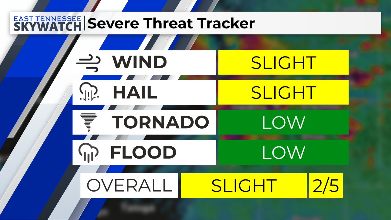 Here's the week ahead for East Tennessee. Keep a close eye on Tuesday, as the potential for severe weather exists, especially from Morristown, points west and south. A squall line will for over middle TN and move east. Attached is the severe threat tracker for Tue PM into Wed AM. We are certainly keeping a close eye on Tuesday. The potential exists for strong to severe storms Tuesday into Wednesday. The area under the greatest risk would be from the Plateau into Knoxville and Chattanooga. Even though the storms may weaken moving east, The Tri-Cities may see some strong to severe storms as well. |
AuthorEast Tennessee SkyWatch Archives
May 2023
|
 RSS Feed
